Product Information
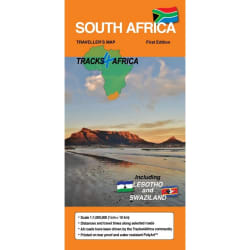
If you plan to travel to a collection of the most popular overland destinations in Southern Africa, then you have to consider the KAZA map. KAZA refers to the world's largest transfrontier land-based conservation area. Spanning the borders of five southern African countries - Angola, Botswana, Namibia, Zambia and Zimbabwe - covering an area of over 519 000km2, it is a treasure trove of natural and cultural wonders. This map brings to life the biggest variety of safari experiences to be had in Southern Africa. Highlights include the Mosi-au-Tunya Falls (Victoria Falls), Okavango Delta and Tsodilo Hills UNESCO World Heritage Sites. The map spans from the Kafue National Park in the north to Makgadikgadi National Park in the south. From Windhoek in the west to Kariba in the east - it really does cover the most attractive self-drive destinations in Southern Africa!
- Large 1:1,000,000 scale (l1cm = 10km)
- Travel times and distances shown on roads
- Large paper map, printed on both sides folds down to easy to use size.
- Packed in a plastic sleeve for extra protection.
- Map designed to suit the needs of selfdrive travellers
- Printed on tear and water resistant PolyArt paper suitable for outdoor use
Tracks4Africa Kavango Zambezi Transfrontier Conservation Area (KAZA) 1st Edition
1016419
If you plan to travel to a collection of the most popular overland destinations in Southern Africa, then you have to consider the KAZA map. KAZA refers to the world's largest transfrontier land-based conservation area. Spanning the borders of five southern African countries - Angola, Botswana, Namibia, Zambia and Zimbabwe - covering an area of over 519 000km2, it is a treasure trove of natural and cultural wonders. This map brings to life the biggest variety of safari experiences to be had in Southern Africa. Highlights include the Mosi-au-Tunya Falls (Victoria Falls), Okavango Delta and Tsodilo Hills UNESCO World Heritage Sites. The map spans from the Kafue National Park in the north to Makgadikgadi National Park in the south. From Windhoek in the west to Kariba in the east - it really does cover the most attractive self-drive destinations in Southern Africa!
- Large 1:1,000,000 scale (l1cm = 10km)
- Travel times and distances shown on roads
- Large paper map, printed on both sides folds down to easy to use size.
- Packed in a plastic sleeve for extra protection.
- Map designed to suit the needs of selfdrive travellers
- Printed on tear and water resistant PolyArt paper suitable for outdoor use


R 150,00
R 159,00