Product Information
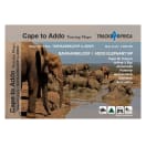
As the name suggests, these two maps stretch from Cape St. Francis in the west to Alexandria in the east. The coastline forms the southern boundary and to the north it includes places like Jansenville and Middleton. The Addo Elephant National Park is world famous and forms the main feature on these two maps. Along with it, the eastern section of the Baviaanskloof is covered, continuing with the Garden Route between Cape St. Francis to Gqeberha (Port Elizabeth). Key ares of interest include places like Cape St. Francis and Jeffrey's Bay for its world-famous surfing. Prominent towns include Humansdorp, Patensie, JAnsenville, Kariega (Uitenhage), Kirkwood,Paterson, Colchester and Alexandria.
- Printed on tear proof and water resistant Duraflex
- Scale 1:200 000
- Folded size: 220mm x 153mm
- Map content is aimed at road trips: car, campervan, motorbike, adventure bike, mountain bike and 4WD
- Services such as accommodation, camping, fuel, shopping and restuarants included
- Activities such as whale watching, hikinh, mountain biking and beaches included
- Scenic routes and mountain passes as well as drive times on roads
Tracks4Africa Cape to Addo Touring Maps - Baviaanskloof to Addo
1016077
As the name suggests, these two maps stretch from Cape St. Francis in the west to Alexandria in the east. The coastline forms the southern boundary and to the north it includes places like Jansenville and Middleton. The Addo Elephant National Park is world famous and forms the main feature on these two maps. Along with it, the eastern section of the Baviaanskloof is covered, continuing with the Garden Route between Cape St. Francis to Gqeberha (Port Elizabeth). Key ares of interest include places like Cape St. Francis and Jeffrey's Bay for its world-famous surfing. Prominent towns include Humansdorp, Patensie, JAnsenville, Kariega (Uitenhage), Kirkwood,Paterson, Colchester and Alexandria.
- Printed on tear proof and water resistant Duraflex
- Scale 1:200 000
- Folded size: 220mm x 153mm
- Map content is aimed at road trips: car, campervan, motorbike, adventure bike, mountain bike and 4WD
- Services such as accommodation, camping, fuel, shopping and restuarants included
- Activities such as whale watching, hikinh, mountain biking and beaches included
- Scenic routes and mountain passes as well as drive times on roads