Product Information
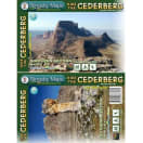
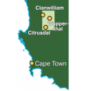
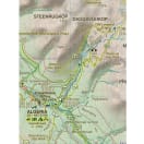
HIKE THE CEDERBERG: There are two double-sided A1-sized maps in the set (i.e. four maps in all), covering the entire Cederberg Wilderness and extending north to Wolfdrif and south to Mount Ceder. The maps are printed on Duraflex waterproof material and are packaged together in a folding slipcase.More than a hundred hikers, mountaineers, conservationists and locals have contributed their special knowledge to the project, which has been proudly endorsed by CapeNature. Every single public footpath has been researched on foot, and the maps include distances between path junctions, as well as GPS coordinates, altitudes, etc
- Popular bouldering sites, as well as the complex of fine mountain biking trails around Dwarsrivier/Sanddrif and other locations
- Caves, perennial water, pools, dramatic rock formations and sites of historical importance (but caves that have rock art are not shown except in super
- Famous Cederberg shalebands, dense vegetation, cedar plantations, prominent rock screes and rockfalls, OVER 12 000 TREES!
- The best places to stay from which your hikes might be launched, with their telephone numbers.
- A1+ x 2 full colour, double-sided maps [four maps]
- Scale 1:40 000 (2.5cm = 1km)
- 20m contours; relief shading
- 10" Long/Lat grid
- Coords in DDMMSS format at all recognised path junctions
- Contact numbers for accommodation and detailed safety information
- WATERPROOF and TEAR RESISTANT in plastic wallet
Slingsby Hike The Cederberg
1010809
HIKE THE CEDERBERG: There are two double-sided A1-sized maps in the set (i.e. four maps in all), covering the entire Cederberg Wilderness and extending north to Wolfdrif and south to Mount Ceder. The maps are printed on Duraflex waterproof material and are packaged together in a folding slipcase.More than a hundred hikers, mountaineers, conservationists and locals have contributed their special knowledge to the project, which has been proudly endorsed by CapeNature. Every single public footpath has been researched on foot, and the maps include distances between path junctions, as well as GPS coordinates, altitudes, etc
- Popular bouldering sites, as well as the complex of fine mountain biking trails around Dwarsrivier/Sanddrif and other locations
- Caves, perennial water, pools, dramatic rock formations and sites of historical importance (but caves that have rock art are not shown except in super
- Famous Cederberg shalebands, dense vegetation, cedar plantations, prominent rock screes and rockfalls, OVER 12 000 TREES!
- The best places to stay from which your hikes might be launched, with their telephone numbers.
- A1+ x 2 full colour, double-sided maps [four maps]
- Scale 1:40 000 (2.5cm = 1km)
- 20m contours; relief shading
- 10" Long/Lat grid
- Coords in DDMMSS format at all recognised path junctions
- Contact numbers for accommodation and detailed safety information
- WATERPROOF and TEAR RESISTANT in plastic wallet