Your Guide to Navigation: Tools, techniques, and GPS Systems
Whatever adventure you are planning ahead - understanding and mastering navigation techniques are arguably some of the most important skills to learn. From hiking to action sports, trail running, sailing, or just driving through cities on road trips - being prepared with the correct navigational tools and knowledge will help you stay on course and avoid trouble so that you can enjoy the outdoor scenery wherever you go.Why is it vital to understand BASIC navigation?
We now rely on our cellphones for nearly everything, and navigation is one of the most useful features that we often take for granted. However, like all technology, you can’t always rely on smartphones to help with navigation. Especially when exploring outdoors, hiking in remote areas, or driving around new places.
Understanding the basics of navigation is a vital skill for any outdoor enthusiast and equipping yourself with the right navigational gear will always help you stay on course and avoid getting lost.
It is always recommended to have several navigation tools at your disposal. While smartphones are great for casual navigation, the outdoors often requires an investment in a reliable GPS system. Having a compass or map as a backup safety measure is highly recommended.
Why you should have a basic compass.
GPS systems could fail during any crucial time of your expedition, overland trip, hike, or adventure. recommended to carry a compass (and map if possible) with you and to know the basics of navigation in case this happens. We recommend the versatile, light, and reliable COGHLAN'S LENSATIC COMPASS which also comes with instructions and helps with using it correctly.
You can browse several other compasses and tools in our navigation range here
Compasses allow you to:
1) Know which direction you are travelling in (usually referred to as your heading)
2) Align or orientate you on a map with your surroundings (referred to as setting the map)
3) To find out which direction an object or destination is from your current position ( which is called its bearing)
4) And lastly, to allow you to follow a straight line of travel (called following a bearing).
Every compass may have different settings or features, so it is important that you always refer to the instructions or manual of the compass you are using, and practice using it before your adventure.
For more information about essential safety gear for your outdoor adventures and our top survival tips, you can read our expert article here:
GPS Gear Review
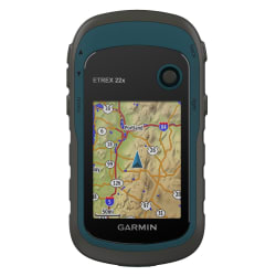
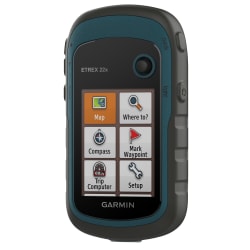
GARMIN ETREX SE
Adventure easily with this simple-to-use GPS handheld with extra battery life, wireless connectivity and multi-GNSS support so you can enjoy exploring more.
Why Buy?
- Bright sunlight is no problem with the high-resolution 2.2" screen.
- Head out more often with up to 168 hours of battery life.
- Into geocaching? Get automatic updates from Geocaching Live to find your next cache.
- Plan trips and more when you pair with the Garmin Explore smart-device app.
- Need accurate tracking? You got it, even in challenging environments with multi-GNSS support.
- Keep your bearings with the digital compass so you are always on course.
- Dimensions: 6.1 x 10.0 x 3.3 cm
- Display Size: 3.3 cm x 4.4 cm
- Dsiplay Resolution: 240 x 320 pixels
- Weight: 156.5 g with batteries
- Water Resistant: IPX7
- Battery Life: 168 hours in standard mode; 1,800 hours in expedition mode
- Memory/History 28MB

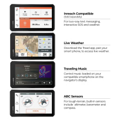
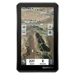
GARMIN GPSMAP 65s
Explore more with this rugged handheld that offers optimal tracking accuracy, a 2.6-inch colour display and preloaded maps.
Why Buy?
- Large 2.6inch sunlight-readable color display for easy viewing
- Display resolution: 160 x 240 pixels
- Expanded global navigation satellite systems (GNSS) and multi-band technology allow you to get optimal accuracy in challenging locations.
- Includes routable TopoActive mapping and federal public land map
- Go-anywhere navigation with 3-axis compass and barometric altimeter
- Compatible with the Garmin Explore website and app (compatible smartphone required) to help you manage tracks, routes and waypoints and review stats
- Multi-band frequency supported maps (TopoActive Africa)
- Memory/history: 16 GB (user space varies based on included mapping)
- Navigate every trail with ABC sensors, including an altimeter for elevation data, barometer to monitor weather and 3-axis electronic compass.
- Smart Notifications: Receive emails, texts and alerts right on your handheld when paired with your compatible device.

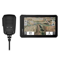
Garmin InReach Mini is a small, palm-sized satellite communicator that lets you stay in touch around the world. It provides 100% global Iridium network two-way messaging and interactive SOS plus basic navigation. Wireless connectivity lets you remotely sync to send/receive messages using compatible Garmin handhelds, wearables, or other mobile devices. Online location tracking with the Earthmate app lets you share your whereabouts with friends or loved ones at home. Optional weather forecasts help you prepare for what's ahead. Pair with select smart devices and Garmin handheld units to access topographic maps, aerial imagery, and other advanced features. The Earthmate app syncs with your smartphone contacts to make staying in touch even easier.
Why Buy?
- Global satellite coverage keeps you connected when mobile phones cant.
- Pocket-Size Communicator: Small, rugged, lightweight device enables two-way text messaging with 100% global Iridium satellite coverage.
- Ultra Rugged: MIL-STD-810-G tested for shock and thermal impact.
- Interactive SOS: Trigger an interactive SOS to the 24/7 GEOS search and rescue monitoring centre .
- Wireless Unit-to-unit Connectivity: Send and receive inReach messages through compatible Garmin devices.
- Location Tracking and Sharing: Track and Shar your location with family and friends.
- Review data on mobile device.
- Great Variability: Offer various mounting options.
- Get Weather Wherever: Optional inReach weather forecast service provides detailed updates directly to your inReach Mini or paired device.
- Battery Performance: Internal, rechargeable lithium battery provides up to 50 hours of battery life in 10-minute tracking mode.
- Water Rating: Rugged, impact resistant and water-rated to IPX7.

Whether it is a family vacation, weekend getaway or your daily commute, the 6inch Garmin DriveSmart 66 navigator brings new levels of freedom, convenience and peace of mind to your time on the road. Garmin voice assist helps you easily find and navigate where you want to go.
Why Buy?
- Easy-to-use, 6 inch navigator includes detailed map updates.
- Simple on-screen menus and bright, clear maps show 3-D buildings and terrain
- Provides real-time services such as live traffic and live parking
- Voice-activated with option to pair with a compatible smartphone for hands-free calling and smart notifications
- Road trip-ready with TripAdvisor traveller ratings and thousands of Foursquare points of interest (POIs)
- Built-in Wi-Fi connectivity for map and software updates without a computer

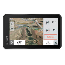
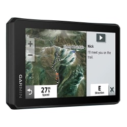
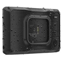
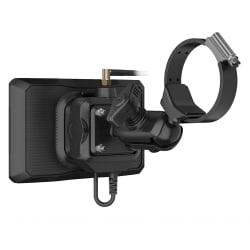
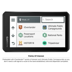
Overlanded is a rugged, multipurpose navigator with a 17.78cm color touchscreen that features turn-by-turn directions for on-road navigation and topography maps for off-grid guidance. Use your Garmin explore account to wirelessly sync your tracks and waypoints across your Overlanded navigator, smartphone and desktop. Built to go wherever the journey takes you, It comes preloaded with Overlanded points of interest, so you can easily locate the next campsite without a cell signal.
Why Buy?
- Display resolution- 1024 x 600 pixels
- Rugged and water-resistant design with button operation
- Preloaded street maps
- Downloadable satellite imagery
- Downloadable USGS Quad Sheets
- Internal storage- 64 GB

Top 10 tips for using your GPS systems.
1) Practice using your GPS before your trip
2) Remember to reset your trip data at the start of every hike or trip
3) If possible, install 24K maps onto your GPS unit
The 100k base maps included with GPS receivers don’t have enough detail to be useful during a hike. Make sure you install 24K Topo maps if they are available for the area you in.
4) Don’t rely on GPS systems only. Always have a backup plan and pack a map and compass with you whenever possible.
5) Always prepare ahead and create a trip plan.
Read more about our Multi-Day Hiking Checklist guide and how to plan a trip on our expert advice article here.
6) Check your position frequently while adventuring
A GPS does absolutely no good if it lives inside your backpack and you never look at it. Carry your GPS within close reach so that you can check it frequently. It also helps to pinpoint your position on your map each time you check, especially in case GPS unit dies or fails on you for some reason.
7) Correctly set the map datum and declination
Whenever you plan a trip or start a hike, make sure to set your GPS map datum to match the datum shown in the legend of your map. A map’s datum is used to calculate the position of its latitude and longitude lines. Different maps use different datums and you want to make sure your GPS is set to the map that you’re using. For any assistance visit our team of experts in-store to assist you with all datum and declination details or to help set this up for you.
8) Don’t trust any GPS system or technology 100%.
Although GPS technology is incredibly advanced and accurate, you can never rely on it to always be 100% accurate. While many GPS units are certified to be accurate to within 10 feet for 95% of the time, depending on the area, they can be way off the other 5% which can quickly lead to confusion on your trip, and again why it is always important to have multiple navigational options at your disposal.
9) Remember to bring spare batteries or charging units.
Although GPS units have long battery lives - on long trips these can easily run out and if you do not plan ahead, could leave you off track when you least expect. It’s best to bring spare batteries with you in case you run out of juice during a hike. Lithium-ion batteries last longer than alkaline batteries and are resistant to cold weather. We recommend the useful Zartek Spare Battery as a great backup - but always check with your specific unit or ask out in-store experts for advice on always staying charged on your adventures

10) Don’t always follow the shortest distance on your GPS
While a GPS will point you in the right direction, this is often not the best or easy route to follow. Because of different types of terrain or scenery, it is sometimes best to take a longer route that is more reliable. It is also always suggested to refer to maps and any other information about the place you will be using your GPS.
Our In-Store GPS Services.
Streets, businesses, and maps change often, so ensure that you have updated your GPS system before your trip.
Make sure you have the latest detailed street maps and points of interest to ensure quick, easy, and accurate navigation. Whether you have lifetime updates, need to purchase an update, or aren’t sure – get started by downloading Garmin Express or visiting us in-store for our team of experts to help set you up with any updates or advice you need.
Our expert staff members are qualified to help you choose the perfect unit, whether for personal navigation or outdoor activities as diverse as automotive, marine, fitness, and geocaching.
We can provide extra or updated local and international GPS maps and software, while you wait, at our in-store online navigation station. Plus we stock the widest range of GPS accessories, including traffic info receivers. All this goes to earn us valued accreditation as a Garmin Specialist Centre.