Product Information
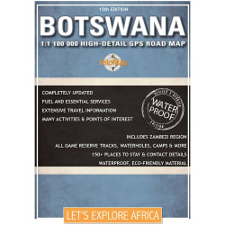
The Tracks4Africa Botswana paper map, now in its 4th edition, is designed to be used in conjunction with the Tracks4Africa GPS Map of Botswana. It is the largest available Botswana map at 1:1,000,000 scale, offering you the perfect trip planning tool for your next Botswana holiday. This Tracks4Africa paper map series are probably the first comprehensive country maps in the world, offering travel time information for the entire road network, be it on tar, gravel or sand!
- Printed on tear proof and water resistant Polyart
- Scale 1:1,000,000 (1cm = 10km)
- All roads have been driven by the Tracks4Africa Community
- Map key included
- Map index included
- Detailed vector maps of the Okavango Delta, Mabuasehube, Savuti, Gaborone, Maun, Kasane, Khwai East and West
- Travel information like border post red tape, camping etiquette, driving in Botswana, fuel, useful contact numbers etc.
- Distances and travel times between towns are indicated
- Main services indicated with icons in main towns
- Border Controls with opening and closing times
- Detailed maps eg. Gaborone
Tracks4africa Botswana Map 4th edition
1005737
The Tracks4Africa Botswana paper map, now in its 4th edition, is designed to be used in conjunction with the Tracks4Africa GPS Map of Botswana. It is the largest available Botswana map at 1:1,000,000 scale, offering you the perfect trip planning tool for your next Botswana holiday. This Tracks4Africa paper map series are probably the first comprehensive country maps in the world, offering travel time information for the entire road network, be it on tar, gravel or sand!
- Printed on tear proof and water resistant Polyart
- Scale 1:1,000,000 (1cm = 10km)
- All roads have been driven by the Tracks4Africa Community
- Map key included
- Map index included
- Detailed vector maps of the Okavango Delta, Mabuasehube, Savuti, Gaborone, Maun, Kasane, Khwai East and West
- Travel information like border post red tape, camping etiquette, driving in Botswana, fuel, useful contact numbers etc.
- Distances and travel times between towns are indicated
- Main services indicated with icons in main towns
- Border Controls with opening and closing times
- Detailed maps eg. Gaborone
R 159,00

R 159,00