


Product Information
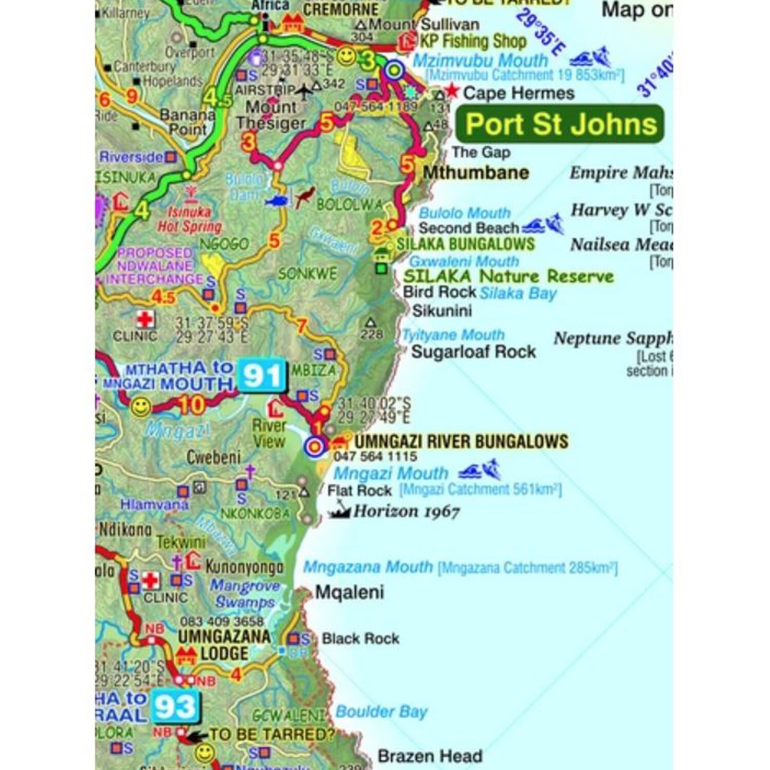
The Wild Coast is a wilderness paradise, strewn with natural wonders. Over one hundred lagoons thread this romantic coast, pristine beaches await fishermen, surfers and holiday makers; mighty waterfalls plunge directly into the sea, rivers gouge deep secret valleys into this heartland of South Africas history. Birthplace and resting place of Nelson Rolihlahla Mandela, this extraordinary landscape is where visions were dreamed, battles fought, ships came to dramatic ends.
- All roads from National Highways to minor gravel roads: 10 classifications that indicate the quality of each road, helping you to plan your route
- Distances clearly shown between road-junctions, and GPS coordinates for every road-junction
- Specific landmarks in a land where road-signs are few and far between.
- These landmarks include schools, clinics, stores, radio masts and all the police stations, with their telephone numbers
- The very latest information about the route of the N2 Toll Road
- The Nelson Mandela Legacy Bridge and the tarred road to Mvelo is shown
- All tourism accommodation, as well as the telephone numbers
- A large range of facilities from hiking opportunities to horse riding, mountain biking, surfing, fishing etc.
- Nearly one hundred shipwrecks, many with brief notes about what happened there
- The size of the catchments of the major rivers, as well as the heights of selected waterfalls.
- Important battlefields from the wars of the 19th Century.
- A1 double-sided full colour map
- Scale 1:200 000 (5cm = 10km)
- 20m contours; relief shading; height shading
- 1' Long/Lat grid
- Coords in DD MM SS format at every road-junction
- WATERPROOF and TEAR RESISTANT in plastic sleeve
Slingsby West Coast Touring Map
1010808
The Wild Coast is a wilderness paradise, strewn with natural wonders. Over one hundred lagoons thread this romantic coast, pristine beaches await fishermen, surfers and holiday makers; mighty waterfalls plunge directly into the sea, rivers gouge deep secret valleys into this heartland of South Africas history. Birthplace and resting place of Nelson Rolihlahla Mandela, this extraordinary landscape is where visions were dreamed, battles fought, ships came to dramatic ends.
- All roads from National Highways to minor gravel roads: 10 classifications that indicate the quality of each road, helping you to plan your route
- Distances clearly shown between road-junctions, and GPS coordinates for every road-junction
- Specific landmarks in a land where road-signs are few and far between.
- These landmarks include schools, clinics, stores, radio masts and all the police stations, with their telephone numbers
- The very latest information about the route of the N2 Toll Road
- The Nelson Mandela Legacy Bridge and the tarred road to Mvelo is shown
- All tourism accommodation, as well as the telephone numbers
- A large range of facilities from hiking opportunities to horse riding, mountain biking, surfing, fishing etc.
- Nearly one hundred shipwrecks, many with brief notes about what happened there
- The size of the catchments of the major rivers, as well as the heights of selected waterfalls.
- Important battlefields from the wars of the 19th Century.
- A1 double-sided full colour map
- Scale 1:200 000 (5cm = 10km)
- 20m contours; relief shading; height shading
- 1' Long/Lat grid
- Coords in DD MM SS format at every road-junction
- WATERPROOF and TEAR RESISTANT in plastic sleeve
R 150,00
R 159,00
R 149,00